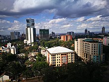
Are you looking to outsource your cleaning task and are wondering which is the Most affordable cleaning services company in Nairobi, Kenya? Arrow FM Cleaning services Ltd is among the best cleaning companies in Nairobi, offering the most reliable cleaning services. We have partnered with other premium service providers to offer you convenience, Quality, and value all under one roof. Our workplace support services are diverse, with our main area of specialty being the provision of Home/office cleaning services in Nairobi, facilities management Services, gardening/landscaping services, Post-construction Cleaning, Common area cleaning services, Carpet Cleaning services, and pest control services. we have partnered with other experts to ensure we deliver quality and value consistently.
Our ability to deliver outstanding services for our clients starts with our team of well trained, smart, and experienced stewards. As unique as we are individually, we share a mutual passion for providing you with the best cleaning services in Nairobi. Our purpose is to provide employment opportunities to individuals who share our core values which are service, professionalism, honesty, friendliness, and quality.
We are a Reliable, Professional Cleaning Services Company in Nairobi Kenya. Offering the best quality cleaning services that guarantee our customer professional cleaning services at an affordable cost.
We at Arrow FM Cleaning Services, aim to surpass our client’s expectations and deliver professionally cleaned homes, offices, common areas, carpets, upholstery, events, and swimming pools on each assignment. The quality of our services surpasses other cleaning services companies in Kenya.
We have invested our time and effort to become your preferred cleaning services company in Nairobi, Kenya. Offering unmatched value to our clients.
Office Cleaning Services
A clean office is a productive office – and it is more appealing to your employees, customers and vendors too. However, keeping the office clean and fresh is a job no one wants. Let us take over the routine cleaning and we’ll give you an office that everyone will appreciate. After all we are the best cleaning company in Nairobi.
House Cleaning Services
Dusting, vacuuming, scrubbing and washing floors and windows. These are just a few of the jobs around your home that can become a bit overwhelming and take away from your free time. Contact us for affordable cleaning services in Nairobi, Let us take over these tasks and you can just relax and enjoy a nice clean home
Post Construction Cleaning Services
Completing a construction or remodeling project is a lot of work, but most people don’t realize that completing a renovation project is only half the job. Post-Construction Cleaning Services from Arrow Facilities Management Ltd will get your space back to working order
Gardening and landscaping Services
We supply and provide maintenance services of both indoor and out door plants. We also design and create manicured lawns serene gardens as well as grounds maintenance i.e. mowing of grass lawns, pruning, weeding of flower beds, hedge trimming, etc
Washroom Management Services
We make sure that your washrooms always look clean, smell fresh and stay hygienic, with washroom solutions that keep track of your unique needs, from everyday essentials like toilet tissue, air fresheners, crème soap, feminine hygiene bins and hand towels to luxury items like hand lotion, room sprays, and toilet seat sanitizers.
Pest Control/ Fumigation Services
Pests such as rodents, termites, ants, spiders, cockroaches, and the occasional invaders such as Nairobi flies, centipedes, and millipedes can cause property damage and carry health risks to our families and employees. Speak to us today for your customized pest control solutions.
Carpet/ Upholstery Cleaning Services
We are experts in the carpet and rug cleaning and to retain such position we deliver state-of-the-art service using the most recent technology advances, an organized cleaning process, and eco-friendly solutions for managing stains over fragile materials
Facilities Management Services
We provide a wide variety of commercial cleaning solutions to ensure that your property is always neat, clean and professionally maintained at all times. Our primary services include but not limited to Washroom management, floor cleaning services, window cleaning services, Facilities management services, Parking area cleaning services
Nairobi is the capital and the largest city of Kenya. The name comes from the Maasai phrase Enkare Nairobi, which translates to “cool water”, a reference to the Nairobi River which flows through the city. The city had a population of 4,397,073 in the 2019 census, while the metropolitan area has a population of 9,354,580. The city is popularly referred to as the Green City in the Sun.
Nairobi was founded in 1899 by the colonial authorities in British, as a rail depot on the Ugandan Railway. The town quickly grew to replace Mombasa as the capital of Kenya in 1907. After independence in 1963, Nairobi became the capital of the Republic of Kenya During Kenya’s colonial period, the city became a centre for the colony’s Coffee, Tea and sisal industry. The city lies on the Sabaki river in the southern part of the country and has an elevation of 1,795 meters (5,889 ft) above sea level.
According to the 2019 census, in the administrative area of Nairobi, 4,397,073 inhabitants lived within 696 km2 (269 sq mi).
Home to thousands of Kenyan businesses and over 100 major international companies and organizations, including the United Nations Environment Programme (UN Environment) and the United Nations Office at Nairobi (UNON), Nairobi is an established hub for business and culture. The Nairobi Securities Exchange (NSE) is one of the largest in Africa and the second-oldest exchange on the continent. It is Africa’s fourth-largest exchange in terms of trading volume, capable of making 10 million trades a day.
Nairobi is found within the Greater Nairobi Metropolitan region, which consists of 5 out of 47 counties in Kenya, which generates about 60% of the entire nation’s GDP. The counties are:
| Area | County | Area (km2) | Population census 2019 | Cities/towns/municipalities in the Counties |
|---|---|---|---|---|
| Core Nairobi | Nairobi County | 696 | 4,397,073 | Nairobi |
| Northern Metro | Kiambu County | 2,449.2 | 2,417,735 | Kiambu, Thika, Limuru, Ruiru, Karuri, Kikuyu, Ruaka, Kahawa and Githunguri |
| North Eastern Metro | Murang’a County | 2,325.8 | 1,056,640 | Gatanga, Kandara, Kenol/Kabati, Murang’a |
| Southern Metro | Kajiado County | 21,292.7 | 1,107,296 | Kajiado, Olkejuado, Bissil, Ngong, Kitengela, Kiserian, Ongata Rongai |
| Eastern Metro | Machakos County | 5,952.9 | 1,421,932 | Kangundo-Tala, Machakos, Athi River |
| Totals | Nairobi Metro | 32,715.5 | 10,411,220 |
History
Early years
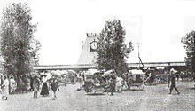
Entrance to Nairobi railway station in 1899
During the pre-colonial era, the people of Kenya lived in villages amongst their tribes and cultures where they had rulers within their communities rather than a president and lived in that manner.
In 1898, Arthur Church was commissioned to design the first town layout for the railway depot. It constituted two streets – Victoria Street and Station Street, ten avenues, staff quarters, and an Indian commercial area. The railway arrived at Nairobi on 30 May 1899, and soon Nairobi replaced Machakos as the headquarters of the provincial administration for Ukamba province. On the arrival of the railway, Whitehouse remarked that “Nairobi itself will in the course of the next two years become a large and flourishing place and already there are many applications for sites for hotels, shops and houses. The town’s early years were however beset with problems of malaria leading to at least one attempt to have the town moved. In the early 1900s, Bazaar Street (now Biashara Street) was completely rebuilt after an outbreak of plague and the burning of the original town.
Between 1902 and 1910, the town’s population rose from 5,000 to 16,000 and grew around administration and tourism, initially in the form of big game hunting. In 1907, Nairobi replaced Mombasa as the capital of the East Africa Protectorate. In 1908, a further outbreak of the plague led to Europeans concluding that the cause was unhygienic conditions in the Indian Bazaar. The government responded by restricting lower class Indians and African natives to specific quarters for residence and trade setting a precedent for racial segregation in the commercial sphere. By the outset of the First World War, Nairobi was well established as a European settler colony through immigration and land alienation. In 1919, Nairobi was declared to be a municipality.
Growth
In 1921, Nairobi had 24,000 residents, of which 12,000 were native Africans. The next decade would see a growth in native African communities into Nairobi, where they would go on to constitute a majority for the first time. Due to this growth, the blend of the mixed ethnicities within the town’s boundaries caused planning issues; Thorntorn White and his planning team would have described it as the “Nairobi Problem”. In February 1926, colonial officer Eric Dutton passed through Nairobi on his way to Mount Kenya, and said of the city:
Maybe one day Nairobi will be laid out with tarred roads, with avenues of flowering trees, flanked by noble buildings; with open spaces and stately squares; a cathedral worthy of faith and country; museums and of art; theatres and public offices. And it is fair to say that the Government and the Municipality have already bravely tackled the problem and that a town-plan ambitious enough to turn Nairobi into a thing of beauty has been slowly worked out, and much has already been done. But until that plan has borne fruit, Nairobi must remain what she was then, a slatternly creature, unfit to queen it over so lovely a country.
The continuous expansion of the city began to anger the Maasai, as the city was devouring their land to the south. It also angered the Kikuyu people, who wanted the land returned to them. After the end of World War II, this friction developed into the Mau Mau rebellion. Jomo Kenyatta, Kenya’s future president, was jailed for his involvement even though there was no evidence linking him to the rebellion. The pressure exerted from the locals onto the British resulted in Kenyan independence in 1963, with Nairobi as the capital of the new republic.
Post independence
After independence, Nairobi grew rapidly and this growth put pressure on the city’s infrastructure. Power cuts and water shortages were a common occurrence, though in the past few years better city planning has helped to put some of these problems in check.
On 11 September 1973, the Kenyatta International Conference Centre KICC was open to the public. The 28-storey building at the time was designed by the Norwegian architect Karl Henrik Nøstvik and Kenyan David Mutiso. The construction was done in three phases. Phase I was the construction of the podium, Phase II consisted of the main tower, and Phase III involved the Plenary. Construction was completed in 1973, with the opening ceremony occurring on 11 September and being presided over by Kenya’s founding father President Kenyatta. It is the only building within the city with a helipad that is open to the public. Of the buildings built in the Seventies, the KICC was the most eco-friendly and most environmentally conscious structure; its mainframe was constructed with locally available materials gravel, sand, cement and wood, and it had wide-open spaces which allowed for natural aeration and natural lighting. Cuboids made up the plenary hall, the tower consisted of a cylinder composed of several cuboids, and the amphitheater and helipad both resembled cones. The tower was built around a concrete core and it had no walls but glass windows, which allowed for maximum natural lighting. It had the largest halls in eastern and central Africa.
Three years prior in 1972, the World Bank approved funds for further expansion of the then Nairobi Airport (now Jomo Kenyatta International Airport), including a new international and domestic passenger terminal building, the airport’s first dedicated cargo and freight terminal, new taxiways, associated aprons, internal roads, car parks, police and fire stations, a State Pavilion, airfield and roadway lighting, fire hydrant system, water, electrical, telecommunications and sewage systems, a dual carriageway passenger access road, security, drainage and the building of the main access road to the airport (Airport South Road). The total cost of the project was more than US$29 million (US$111.8 million in 2013 dollars). On 14 March 1978, construction of the terminal building was completed on the other side of the airport’s single runway and opened by President Jomo Kenyatta less than five months before his death. The airport was renamed Jomo Kenyatta International Airport in memory of its first president.
Contemporary
On 9 November 2012, President Mwai Kibaki opened the KES 31 billion Thika Superhighway. This mega-project of Kenya started in 2009 and ended in 2011. It involved expanding the four-lane carriageway to eight lanes, building underpasses, providing interchanges at roundabouts, erecting flyovers, and building underpasses to ease congestion. The 50.4-kilometer road was built in three phases: Uhuru Highway to Muthaiga Roundabout; Muthaiga Roundabout to Kenyatta University and; Kenyatta University to Thika Town.
On 31 May 2017, the current president Uhuru Kenyatta inaugurated the Standard Gauge Railway which runs from Nairobi to Mombasa and vice versa. It was primarily built by a Chinese firm with about 90% of total funding from China and about 10% from the Kenyan government. A second phase is also being built which will link Naivasha to the existing route and also the Uganda border.
Historical population data for Nairobi
| Year | 1969 | 1979 | 1989 | 1999 | 2009 | 2019 |
|---|---|---|---|---|---|---|
| Nairobi | 509,286 | 827,775 | 1,324,570 | 2,143,254 | 3,138,369 | 4,397,073 |
Geography
The city is situated at 1°09′S 36°39′E and 1°27′S 37°06′E and occupies 696 square kilometers (270 sq mi).
Nairobi is situated between the cities of Kampala and Mombasa. As Nairobi is adjacent to the eastern edge of the Rift Valley, minor earthquakes and tremors occasionally occur. The Ngong Hills, located to the west of the city, is the most prominent geographical feature of the Nairobi area. Mount Kenya is situated north of Nairobi, and Mount Kilimanjaro is towards the south-east.
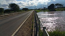
The Nairobi River and its tributaries traverse through the Nairobi County and joins the larger River Athi on the eastern edge of the county.
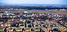
Rain clouds over estates (Dec. 2019).
Nobel Peace Prize laureate Wangari Maathai fought fiercely to save the indigenous Karura Forest in northern Nairobi which was under threat of being replaced by housing and other infrastructure.
Nairobi’s western suburbs stretch all the way from the Kenyatta National Hospital in the south to the UN headquarters at Gigiri suburb in the north, a distance of about 20 kilometres (12 mi). The city is centred on the City Square, which is located in the Central Business District. The Kenyan Parliament buildings, the Holy Family Cathedral, Nairobi City Hall, Nairobi Law Courts, and the Kenyatta Conference Centre all surround the square.
Climate
Under the Köppen climate classification, Nairobi has a subtropical highland climate (Cwb). At 1,795 metres (5,889 ft) above sea level, evenings may be cool, especially in the June/July season, when the temperature can drop to 9 °C (48 °F). The sunniest and warmest part of the year is from December to March, when temperatures average in the mid-twenties Celsius during the day. The mean maximum temperature for this period is 24 °C (75 °F).[39]
There are rainy seasons, but rainfall can be moderate. The cloudiest part of the year is just after the first rainy season, when, until September, conditions are usually overcast with drizzle. As Nairobi is situated close to the equator, the differences between the seasons are minimal. The seasons are referred to as the wet season and dry season. The timing of sunrise and sunset varies a little throughout the year for the same reason.[40]
Districts and neighborhoods
Nairobi southern suburbs
Nairobi is divided into a series of constituencies with each being represented by members of Parliament in the National Assembly. These constituencies are: Makadara, Kamukunji, Starehe, Langata, Dagoretti, Westlands, Kasarani, and Embakasi. The main administrative divisions of Nairobi are Central, Dagoretti, Embakasi, Kasarani, Kibera, Makadara, Pumwani, and Westlands. Most of the upmarket suburbs are situated to the west and north-central of Nairobi, where most European settlers resided during the colonial times’ AKA ‘Ubabini’. These include Karen, Langata, Lavington, Gigiri, Muthaiga, Brookside, Spring Valley, Loresho, Kilimani, Kileleshwa, Hurlingham, Runda, Kitisuru, Nyari, Kyuna, Lower Kabete, Westlands, and Highridge, although Kangemi, Kawangware, and Dagoretti are lower-income areas close to these affluent suburbs. The city’s colonial past is commemorated by many English place-names.
Most lower-middle and upper middle income neighbourhoods are located in the north-central areas such as Highridge, Parklands, Ngara, Pangani, and areas to the southwest and southeast of the metropolitan area near the Jomo Kenyatta International Airport. The most notable ones include Avenue Park, Fedha, Pipeline, Donholm, Greenfields, Nyayo, Taasia, Baraka, Nairobi West, Madaraka, Siwaka, South B, South C, Mugoya, Riverbank, Hazina, Buru Buru, Uhuru, Harambee Civil Servants‘, Akiba, Kimathi, Pioneer, and Koma Rock to the centre-east and Kasarani to northeast area among others. The low and lower income estates are located mainly in far eastern Nairobi. These include, Umoja, Kariokor, Dandora, Kariobangi, Kayole, Embakasi, and Huruma. Kitengela suburb, though located further southeast, Ongata Rongai and Kiserian further southwest, and Ngong/Embulbul suburbs also known as ‘Diaspora’ to the far west are considered part of the Greater Nairobi Metropolitan area. More than 90% of Nairobi residents work within the Nairobi Metropolitan area, in the formal and informal sectors. Many Somali immigrants have also settled in Eastleigh, nicknamed “Little Mogadishu”.
Kibera slum
The Kibera slum in Nairobi (with an estimated population of at least 500,000 to over 1,000,000 people) was thought to be Africa’s second-largest slum. However, recent census results have shown that Kibera is indeed much smaller than originally thought.
Parks and gardens
Kenyatta Avenue with Uhuru Park between Upper Hill and the Nairobi CBD
Nairobi has many parks and open spaces throughout the city. Much of the city has dense tree-cover and plenty of green spaces. The most famous park in Nairobi is Uhuru Park. The park borders the central business district and the neighborhood Upper Hill. Uhuru (Freedom in Swahili) Park is a centre for outdoor speeches, services, and rallies. The park was to be built over by former President Daniel arap Moi, who wanted the 62-storey headquarters of his party, the Kenya African National Union, situated in the park.[49] However, the park was saved following a campaign by Nobel Peace Prize winner Wangari Maathai.
Central Park is adjacent to Uhuru Park, and includes a memorial for Jomo Kenyatta, the first president of Kenya, and the Moi Monument, built in 1988 to commemorate the second president’s first decade in power. Other notable open spaces include Jeevanjee Gardens, City Park, 7 August Memorial Park, and Nairobi Arboretum.
The colonial 1948 Master Plan for Nairobi still acts as the governing mechanism when it comes to making decisions related to urban planning. The Master Plan at the time, which was designed for 250,000 people, allocated 28% of Nairobi’s land to public space, but because of rapid population growth, much of the vitality of public spaces within the city are increasingly threatened.[50] City Park, the only natural park in Nairobi, for example, was originally 150 acres, but has since lost approximately 50 acres of land to private development through squatting and illegal alienation which began in the 1980s.[50][51]
Political divisions
The City of Nairobi enjoys the status of a full administrative County.
The Nairobi province differs in several ways from other Kenyan regions. The county is entirely urban. It has only one local council, Nairobi City Council. Nairobi Province was not divided into “districts” until 2007, when three districts were created. In 2010, along with the new constitution, Nairobi was renamed a county.
Nairobi County has 17 constituencies. Constituency name may differ from division name, such that Starehe Constituency is equal to Central Division, Lang’ata Constituency to Kibera division, and Kamukunji Constituency to Pumwani Division in terms of boundaries.
Constituencies
Nairobi is divided into 17 constituencies and 85 wards, mostly named after residential estates. Kibera Division, for example, includes Kibera (Kenya’s largest slum) as well as affluent estates of Karen and Langata.
| Constituency | Communities |
|---|---|
| Westlands | Kitisuru · Parklands/Highridge · Karura · Kangemi · Mountain View |
| Dagoretti North | Kilimani · Kawangware · Gatina · Kileleshwa · Kabiro |
| Dagoretti South | Mutu-ini · Ngand’o · Riruta · Uthiru/Ruthimitu · Waithaka |
| Langata | Karen · Nairobi West · Ngumo · South C · Nyayo Highrise · Otiende · Sunvalley I/II. · st.Mary’s Hospital· Royal Park |
| Kibra | Laini Saba · Lindi · Makina · Woodley/ Kenyatta Golf Course · Sarang’ombe |
| Roysambu | Roysambu · Garden Estate · Muthaiga · Ridgeways · Githurai · Kahawa West · Zimmermann · Kahawa |
| Kasarani | Clay City · Mwiki · Kasarani · Njiru · Ruai |
| Ruaraka | Babadogo · Utalii · Mathare North · Lucky Summer · Korogocho |
| Embakasi South | Imara Daima · Kwa Njenga · Kwa Reuben · Pipeline · Kware |
| Embakasi North | Kariobangi North · Dandora Area I · Dandora Area II · Dandora Area III · Dandora Area IV |
| Embakasi Central | Kayole North · Kayole North Central · Kayole South · Komarock · Matopeni/ Spring Valley |
| Embakasi East | Upper Savanna · Lower Savanna · Embakasi · Utawala · Mihang’o |
| Embakasi West | Umoja I · Umoja II · Mowlem · Kariobangi South |
| Makadara | Maringo/ Hamza · Viwandani · Harambee · Makongeni · Mbotela · Bahati |
| Kamukunji | Pumwani · Eastleigh North · Eastleigh South · Airbase · California |
| Starehe | Nairobi Central · Ngara · Pangani · Ziwani/ Kariokor · Landimawe · Nairobi South |
| Mathare | Hospital · Mabatini · Huruma · Ngei · Mlango Kubwa · Kiamaiko |
Economy
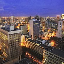
Central business district and skyline
Nairobi has grown around its central business district. This takes a rectangular shape, around the Uhuru Highway, Haille Selassie Avenue, Moi Avenue, and University Way. It features many of Nairobi’s important buildings, including the City Hall and Parliament Building. The city square is also located within the perimeter.
Most of the skyscrapers in this region are the headquarters of businesses and corporations, such as I&M and the Kenyatta International Conference Centre.
In 2011, the city was considered to have about 4 million residents. A large beautification project took place in the Central Business District, as the city prepared to host the 2006 Afri-Cities summit. Iconic buildings such as the Kenyatta International Conference Centre had their exteriors cleaned and repainted.
Nairobi downtown area or central business district is bordered to the southwest by Uhuru Park and Central Park. The Mombasa to Kampala railway runs to the southeast of the district.
Upper Hill
Prism Tower in Upper Hill
Two areas outside of the Central Business District area that are seeing a growth in companies and office space are Upper Hill, which is located, approximately 4 km (2.5 mi) from the Central Business District and Westlands, which is also about the same distance, away from the city center.
Companies that have moved from the Central Business District to Upper Hill include Citibank and in 2007, Coca-Cola began construction of their East and Central African headquarters in Upper Hill,[65] cementing the district as the preferred location for office space in Nairobi. The largest office development in this area is UAP Tower, completed recently in 2015 and officially opened for business on July 4, 2016.[66] It is a 33-storey tower and reaches a height of 163 meters. The World Bank and International Finance Corporation (part of the World Bank Group) are also located in Upper Hill at the Delta Center, Menegai Road. Earlier on, they were located in the Hill Park Building and CBA Building respectively (both also in Upper Hill), and prior to that in View Park towers in the Central Business District.
To accommodate the large demand for floor space in Nairobi, various commercial projects are being constructed. New business parks are being built in the city, including the flagship Nairobi Business Park.
Construction boom and real estate development projects
A view of Nairobi from the Kenyatta International Conference Centre
Nairobi is undergoing a construction boom. Major real estate projects and skyscrapers are coming up in the city. Among them are: The pinnacle twin towers which will tower at 314 m, Britam Tower (200 m), Avic International Africa headquarters (176 m), Prism tower (140 m), Pan Africa insurance towers, Pallazzo offices, and many other projects. Shopping malls are also being constructed like the recently completed Garden city Mall, Centum’s Two rivers Mall, The Hub in Karen, Karen waterfront, Thika Greens, and the recently reconstructed Westgate Mall. High-class residential apartments for living are coming up like Le Mac towers, a residential tower in Westlands Nairobi with 23 floors. Avic International is also putting up a total of four residential apartments on Waiyaki way: a 28-level tower, two 24-level towers, and a 25-level tower. Hotel towers are also being erected in the city. Avic International is putting up a 30-level hotel tower of 141 m in the Westlands. The hotel tower will be operated by Marriot group. Jabavu limited is constructing a 35 floor hotel tower in Upper Hill which will be high over 140 metres in the city skyline. Arcon Group Africa has also announced plans to erect a skyscraper in Upper hill which will have 66 floors and tower over 290 metres, further cementing Upper hill as the preferred metropolis for multinational corporations launching their operations in the Kenyan capital.
| Pinnacle Towers (estimated completion in 2020) | 314 m (1,030 ft) |
| Britam Tower | 200 m (660 ft) |
| UAP Tower | 163 m (535 ft) |
| Times Tower | 140 m (460 ft) |
| Teleposta Towers | 120 m (390 ft) |
| Kenyatta International Conference Centre | 105 m (344 ft) |
| NSSF Building | 103 m (338 ft) |
| I&M Bank Tower | 100 m (330 ft) |
| Nyayo House | 84 m (276 ft) |
| Cooperative Bank House | 83 m (272 ft) |
| National Bank House | 82 m (269 ft) |
| Hazina Towers | 81 m (266 ft) |
| Rahimtulla Tower | 80 m (260 ft) |
Demographics
Nairobi has experienced one of the highest growth rates of any city in Africa. Since its foundation in 1899, Nairobi has grown to become the second-largest city in the African Great Lakes, despite being one of the youngest cities in the region. The growth rate of Nairobi is 4.1% a year.[68] It is estimated that Nairobi’s population will reach 5 million in 2025.[69]
These data fit remarkably closely (r^2 = 0.9994) to a logistic curve with t(0) = 1900, P(0)=8500, r = 0.059 and K = 8,000,000. This suggests a 2011 growth rate of 3.5% (the CIA estimate of 4.5% cited above would have been true in 2005). According to this curve, the population of the city will be below 4 million in 2015, and will reach 5 million in 2025.
Given this high population growth, owing itself both to urban migration and high birth rates, the economy has yet to catch up. Unemployment is estimated at 40% within the city, mainly in the high-density, low-income areas of the city which can make them seem even denser than the higher-income neighborhoods.[70]
Parks
A giraffe at Nairobi National Park, with Nairobi’s skyline in the background
- Nairobi National Park
- Uhuru Park


